Aerodyne Logo

Other Solutions

Digital Transformation Drone Technology Data Technology

We offer services that capture high-resolution three-dimensional terrain measurements with precision and accuracy — and vertically integrated to add value to your industry. Our end-to-end solution provides actionable data to our customers.

Oil and Gas

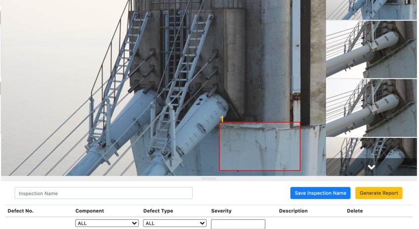
  1. Visual inspection, thermal inspection and confined space inspection
  2. CP monitoring 
  3. Gas leak detection
  4. Ultrasonic thickness inspection
Increase in uptime and reliability
0 %
Cost saving in project equipment
0 %
VertikalitiENERGY is Oil and Gas asset management platform powered by drone technology and machine learning data technology

vertikalitiENERGY

Cloud-based O&G infrastructure inspection and management solutions.

Architect Engineering & Constructions

  1. Visual and structural inspections of various critical infrastructures for Architecture, Engineering and Construction (AEC).
  2. Inspection and monitoring platform.
  3. Defect marking and integrate with inspection and maintenance workflows.
Proven cost savings of up to on slopes inspection
0 %
Superior 3D modelling and digital twin of assets
3 D

vertikalitiINFRA

AI-enabled platform that is capable of identifying faults such as cracks, wear etc.

Precision Agriculture

  1. The use of new technologies such as drones and IoT to increase crop yields and profitability.
  2. Lowering the levels of traditional inputs needed to grow crops (land, water, fertilizer, herbicides and insecticides).
Increase in crop yields*
0 %
Reduction in cost of food production*
0 %
Drone precision agriculture

vertikalitiAGRI

Digital platform for management of farms or agriculture assets.

*International Food Research Policy Institute